Narrabri Lateral Pipeline EIS
The Narrabri Lateral Pipeline (NLP) project involves the construction, operation (including maintenance), and decommissioning of an underground gas transmission pipeline to connect the approved Narrabri Gas Project (NGP) to the approved Hunter Gas Pipeline (HGP).
Santos has prepared an Environmental Impact Statement (EIS) for the NLP assessing potential impacts to State and Commonwealth matters (matters of national environmental significance). The EIS has been submitted to the NSW Department of Planning, Housing and Infrastructure (DPHI) for assessment in accordance with the bilateral agreement between the Australian and NSW governments.
What is an Environmental Impact Statement (EIS)?
An EIS is a document required to support the application for all major projects in NSW. It assesses the potential environmental, economic and social impacts of a proposed project and helps the community, government agencies, and decision-makers understand the project’s benefits and impacts.
Community participation: have your say
Community participation is an essential part of the assessment process. The NLP EIS will be placed on public exhibition by NSW DPHI from 20 November until 18 December 2025.
The EIS is available for viewing at https://www.planningportal.nsw.gov.au/major-projects/projects/narrabri-lateral-pipeline. Hard copies of the EIS will also be available during the public exhibition period at the following locations:
- Santos Narrabri Shopfront: 125 Maitland Street, Narrabri
- Narrabri Shire Council: 46-48 Maitland Street, Narrabri; and
- Boggabri Library: 82 Wee Waa Street, Boggabri
How to make a submission
To have your say on this project, you must lodge a submission online through the Major Projects Portal before the close of the exhibition period.
When making a submission you will be required to include:
- your full name and address
- the name of the application and the application number (SSI-53307723)
- whether you ‘support’ or ‘object to’ the project, or if you are simply providing comment
- the reasons why you support or object to the project
Resources to help you use the Major Projects Portal are available at www.planningportal.nsw.gov.au/major-projects/help including a step-by-step guide on how to make a submission.
For more information on how you can have your say and how the department will manage and consider submissions, visit the Make a submission page on the Major Projects Portal.
About the Project


NLP route and mapping
To navigate the interactive map, use ctrl + scroll to adjust the zoom. To view the different map layers, click on the checkboxes in the legend.
How will the pipeline be constructed?
Watch the animations below to learn more
Pipeline construction involves a repetitive sequence of activities, which are planned, scheduled and integrated to function as a continuous production process. An overview of the key activities is provided below.
Survey and fencing
Surveyors will mark clearing limits, then temporary gates and fences will be installed where required to allow crew movement while protecting livestock and the surrounding environment. Gateways will be placed along the alignment and between properties as agreed with landholders and stakeholders.
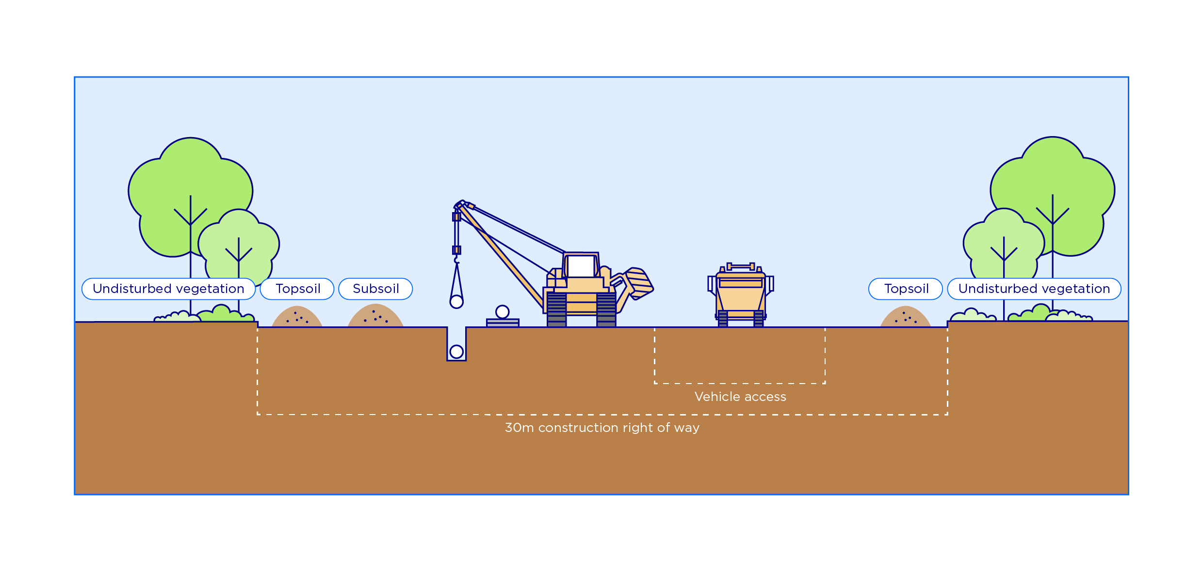
Clear and grade
Clearing and grading will create a safe, level construction surface within a typical 30-metre right of way, adjusted where needed to protect environmental, heritage or land use values. Topsoil and vegetation will be stripped, stockpiled for site restoration or mulched for rehabilitation.
Construction would also include clearing and grading, earthworks, gravel placement where required and installation of drainage for the Baan Baa construction compound and new access track. The Baan Baa compound is the name of our facility which will be used for the storage of pipe, equipment and materials and may include temporary offices, wash bays and maintenance areas.
Pipeline installation
a. Stringing, welding and coating – the pipes are laid out along the right of way which are then lined up and welded together. Weld areas are cleaned, coated and checked for defects to ensure pipeline integrity.
b. Trenching and trenchless installation – most of the pipeline will be installed by trenching using specialised machines, with trenchless construction methods used at a number of watercourses and key road and rail infrastructure. Soils from the trench will be stockpiled separately to topsoil and used for backfilling.
c. Lowering in and backfilling – after trenching, welded pipe strings will be inspected, then lowered into the trench and joined together (tie-ins). The trench is then backfilled and compacted. Open trench lengths are minimised where possible.
d. Trenchless construction methods – trenchless construction methods are used to install pipelines where conventional open trench construction is not feasible or where disturbance to surface environmental features, land use or physical obstacles are to be avoided.
e. Hydrostatic testing – after installation, the pipeline is hydrostatically tested with pressurised water to ensure integrity.
Reinstatement and rehabilitation
a. Following installation of the pipeline, the trench would be progressively backfilled, and topsoil respread as construction progresses along the right of way. Other disturbed areas not required for operation of the project would be reinstated and rehabilitated as soon as practicable after construction is complete.
b. In agricultural areas, rehabilitation would aim to return the land to its former use in consultation with the landholder. Most normal agricultural activities, including cropping, can recommence within the easement following construction.

c. In areas with vegetation, the construction area would be allowed to naturally regenerate. A width of about 20 metres over the pipeline would be maintained to be free of trees to ensure the pipeline is not damaged by roots, and to allow ongoing access.

What did the EIS find?
Noise and vibration
What we found
The main source of potential noise impact will come from construction activities such as clearing and grading, trenching, and installing the underground pipeline. We’ve conducted a detailed noise and vibration assessment following the guidelines set by the NSW Government. We looked at what construction might sound like in different situations such as for transient versus stationary construction activities, and including the worst-case scenarios where multiple construction activities are working at the same time and at the closest point to a nearby home. Most work will happen during the proposed project working hours (6am-6pm, 7-days/week), but some night work will be needed for activities such as trenchless watercourse crossings or hydrostatic testing.
We found that most nearby properties won’t be significantly affected, but a small number of homes could notice some increased noise during construction activities. Our modelling found noise from transient pipeline construction activities would range between 38 dBA and 61 dBA at the most affected home and that even during the noisiest modelled scenarios, no homes are expected to be ‘highly noise affected’ (75 dBA and above). Due to the progression of transient construction activities, noise impacts at individual locations would be short term, typically lasting about one or two days each as the various works progress along the construction corridor.
For stationary construction activities – such as building and using construction ancillary facilities (e.g. Baan Baa construction compound and temporary workspaces), road and watercourse crossings, trenchless crossings and construction of other surface facilities – our modelling shows noise impacts ranging between 30 dBA and 48 dBA at the most affected homes, with the number of homes affected depending on the type of works and timing. No homes are expected to be highly noise affected (75 dBA and above).
Santos will consult with all directly-impacted landholders about potential noise impacts at their property.
Construction-related vibration is not anticipated to impact any homes.
During operations, the main activity to cause noise is pipeline cleaning at the location of the two scraper stations. This is conducted infrequently and is expected to be less than 35 dBA at 110 metres away from the activity. No homes are located within this distance of the scraper stations.
Please refer to Appendix C and D of Technical Report 5 – Noise and Vibration for more information.

Noise level comparisons (Technical Report 5)
How we will manage it
We’re committed to doing everything we reasonably can to minimise noise impacts for the community. Before work starts, we’ll prepare a detailed Construction Noise and Vibration Management Plan. This plan will guide how we reduce and manage noise throughout construction of the project and will include an out-of-hours protocol for any works outside the proposed project working hours. Construction traffic noise will also be managed through driver behaviour, speed limits, and minimising heavy vehicle movements during the early morning. We’ll communicate clearly and early about any work that might cause noticeable noise, especially outside project working hours. We’ll also keep listening to, and working with, nearby residents to manage concerns and respond quickly if noise becomes a problem.
Find out more: Read the Noise and vibration chapter in the EIS
Traffic and transport
What we found
We studied how traffic currently moves on existing roads and railways near the project site, including the State highway network, local roads, and public transport. Our assessment shows that even during the busiest stage of construction, the Newell and Kamilaroi highways are expected to operate well within their capacity. Key intersections within Baan Baa and Narrabri are also expected to operate effectively.
During construction, there will be more vehicles on local roads, especially oversized loads delivering equipment and materials to Leewood and Bibblewindi facilities, the Baan Baa construction compound and the construction right of way.
We will use existing roads and access tracks wherever possible, but in some places we will also need to build new access tracks and upgrade certain roads or intersections to support construction traffic. Access to the Baan Baa construction compound from the Kamilaroi Highway will be upgraded to provide additional turning lanes to ensure the highway will still operate efficiently.
Construction will involve trenching across two local roads (Towri Road and Caloola Road) and unsealed forestry access tracks. These works are expected to take about one to two days each, depending on their width. To ensure the roads can still be used by vehicles during construction, options such as constructing the crossing in halves at separate times or using road plates, would be considered. The Newell Highway and the Mungindi railway line will be crossed using trenchless methods, avoiding disruption to their operation.
Other transport impacts, such as on buses, cyclists, pedestrians, and trains, are expected to be very minor. Our top priority during construction is to minimise disruption for road users and to keep the community safe around our construction areas.
How we’ll manage it
We’ll carefully plan our work to reduce impacts on local residents and road users as much as possible. Our project design will be regularly reviewed to avoid or minimise effects on roads and property access. A detailed Construction Traffic and Access Management Plan will guide how we keep traffic flowing safely and reduce disruptions during construction.
Temporary traffic changes will be clearly signed and communicated in advance. Road and intersection upgrades, such as at the Kamilaroi Highway, will be designed and delivered in consultation with Transport for NSW and Narrabri Shire Council.
Find out more: Read the Traffic and transport chapter in the EIS
Biodiversity
What we found
We prepared a Biodiversity Development Assessment Report (BDAR) to understand the potential impacts of our project on NSW and Commonwealth-listed threatened species and communities. This was carried out in line with the NSW Biodiversity Assessment Methodology (BAM). Since 2023, we’ve carried out seasonal surveys to identify threatened flora, fauna and ecological communities which has helped us refine the pipeline route to avoid or reduce our impacts on threatened species and their habitats wherever possible. We have also been working closely with the NSW Conservation Programs, Heritage and Regulation (CPHR) group regarding our surveys and assessments, especially in areas affected by the December 2023 Duck Creek bushfire.
Our studies found the following:
- Eight different vegetation communities (plant community types (PCT)) in varying condition (low, moderate or high) covering about 80 per cent of the disturbance footprint
- Two threatened ecological communities listed under the NSW Biodiversity Conservation Act 2016 (BC ACT) and three listed under the EPBC Act
- Fifteen threatened flora species listed under the BC Act, which includes eight species also listed under the Environment Protection and Biodiversity Conservation Act 1999 (EPBC Act) potentially impacted
- Fifty threatened fauna species listed under the BC Act, which includes 26 species also listed under the EPBC Act potentially impacted
- Weed species, including five priority weed species, as identified by the Biosecurity Act 2015, 13 high threat weed species, and five weeds of national significance
The main potential for impacts on biodiversity would be during construction from clearing native vegetation (approximately 168 hectares). During operations, the cleared corridor may have connectivity impacts on some fauna species.
How we’ll manage it
We are committed to minimising the potential impacts of the project and are continually investigating opportunities to reduce the disturbance footprint where we can. This approach to design development includes a focus on firstly avoiding and then minimising potential impacts during the design process in accordance with the BAM. The exact amount of vegetation cleared would be refined during detailed design.
We have:
- used disturbance areas associated with other projects, and existing roads to reduce the amount of vegetation clearing required for this project
- aligned the pipeline route through cleared agricultural lands instead of through vegetation as much as possible
- aligned the pipeline route to minimise impacts on identified threatened flora populations
- nominated use of trenchless construction to avoid sensitive areas that include threatened ecological communities, fauna habitat and riparian vegetation
We will:
- aim to avoid clearance of significant habitat trees and hollow-bearing trees in the disturbance footprint where possible
- rehabilitate our disturbance in accordance with our rehabilitation strategy
- offset our impact in accordance with the NSW Biodiversity Offsets Scheme and the Biodiversity Conservation Regulation 2017
- develop a Biodiversity Management Plan including fauna management protocols, and biosecurity management and unexpected finds procedures, to minimise potential impacts on biodiversity during construction
- implement fauna connectivity measures to support fauna movement across the permanent easement
Find out more: Read the Biodiversity chapter in the EIS
Water
What we found
We undertook detailed studies to understand the existing water environment including surface water, groundwater and flooding and the potential impacts from the project.
The project will intersect 45 watercourses, including 33 that would be crossed by the construction right of way via trenching and six where trenchless construction is proposed. Most of the watercourses are minor, and all only flow for a short time during and after rain events (ephemeral creeks). Construction would be short-term, and temporary, and watercourse crossings will be undertaken when there is no flow. We expect minimal impacts to the stability of the watercourse bed and banks, riparian vegetation, aquatic habitat, erosion, sedimentation and downstream water quality and flow during construction.
Our flooding and groundwater studies showed our construction activities may have local and temporary impacts, however no long-term impacts are expected.
Approximately 47 megalitres of water will be needed during construction for activities such as dust suppression, horizontal directional drilling and hydrotesting. Construction water will be sourced using existing Water Access Licence(s) under the Water Management Act 2000. Santos may also use water treated by reverse osmosis from the NGP.
How we’ll manage it
We understand how important it is to protect local watercourses during construction. We’ll follow relevant guidelines and best practices to protect water throughout construction. This includes preparing a detailed Construction Soil and Water Management Plan before work begins. This plan will cover things like erosion and sediment control, and outlines measures such as stabilising soil, managing runoff, and scheduling work to avoid wet periods when erosion risk is higher. We will also only construct (trench) the pipeline through watercourses when they are dry or holding pools, to minimise impacts on flow, water quality and aquatic species. For Bohena, Little Sandy, and Tulla Mullen creeks, we’ll use trenchless construction methods that avoid disturbing the creek beds, banks and riparian vegetation. Extra care will be taken at watercourse crossings, including reinstating creek banks once works are complete.
Construction water will be sourced in line with existing water licences and sustainable allocations. Overall, we’re committed to making sure construction doesn’t harm local water quality and that the environment is restored as quickly as possible once work is finished.
Find out more: Read the Water chapter in the EIS
Land use and agriculture
What we found
We assessed potential impacts on existing and possible future land uses including how it may change as a result of the project, both temporarily during construction and permanently during operation.
The main land use in the disturbance footprint is production native forest (State Forest) (about 114 hectares) within the Pilliga East and Bibblewindi State Forests and agriculture (about 96 hectares), the majority of which is cropping and grazing.
During construction, land use within the disturbance footprint would change from the current use to a temporary construction site, with land used for activities such as the construction right of way, stockpiling and construction facilities. Public access to this land (where it is currently available) would be restricted for the duration of its use as a construction site. Landholders would similarly be temporarily affected while construction moves through their property.
Construction may require the adjustment or relocation of some items of farm infrastructure, such as fencing or gates. These adjustments may be temporary or permanent. Several new access tracks are also proposed within private properties to allow access to the construction right of way.
The extent and significance of potential impacts would vary across individual properties. While there may be a short-term economic impact on agricultural output during construction, landholders would be compensated for any direct loss of agricultural production in accordance with the requirements of the Pipelines Act 1967.
Following construction, the disturbance footprint in agricultural areas (excluding areas required for surface infrastructure for the project) would be reinstated consistent with pre-construction use (or as agreed in consultation with the landholder) in accordance with the rehabilitation strategy. This would include reinstating affected infrastructure (such as fencing and access tracks) as agreed with each landholder.
An easement will be registered on the underlying land title and would remain on title following any future changes in land ownership. The easement proposed for the project is generally 30 metres wide along the length of the pipeline alignment. The easement provides us access to operate and maintain the pipeline. It also places controls on some activities that can be undertaken within the easement, to ensure the safety and reliability of the underground pipeline. No restrictions would be placed on most normal agricultural activities within the easement. Refer HERE for further information on what you can and can’t do within an easement.
Within the State Forests, about 101 hectares would remain unavailable for forestry activities due to the permanent easement. NSW Forestry Corporation would be compensated for the loss of timber resources resulting from the project, as per the terms of the agreement with NSW Forestry Corporation.
How we’ll manage it
We’re committed to working closely with landholders to understand their current and future land use needs and minimise any potential impact. Santos is actively working with landholders along the pipeline to agree on the best alignment, fair compensation, and arrangements that respect individual property uses. Where land is temporarily used during construction, we will make sure it is returned to its original condition as soon as possible. After construction, all equipment and materials will be removed, and the land will be reinstated and rehabilitated in consultation with landholders.
A detailed rehabilitation strategy will guide this process, ensuring disturbed areas are properly restored and maintained, except for permanent surface infrastructure areas. We will also apply biosecurity measures to prevent the spread of weeds, pests, or diseases during construction and operation. Our goal is to protect agricultural productivity and restore land quickly so that farming can continue with minimal impact.
Find out more: Read the Land use and agriculture chapter in the EIS
Air quality and greenhouse gas
What we found
During construction, there may be some temporary dust and emissions from activities like clearing, trenching, equipment use and vehicles driving on unsealed roads. These impacts will be short-lived and generally affect only a small number of nearby homes at any one time. Our assessment shows the risk of dust affecting local air quality is low based on the type and scale of activities, distance to receivers and sensitivity of the surrounding environment. Some vehicle exhaust emissions are expected during construction however these would be localised and temporary.
No impacts on air quality are expected once the pipeline is operating. The main operational emissions would be very small gas releases (about two cubic metres) during maintenance activities at the scraper stations (located at each end of the pipeline). These events would be infrequent and only occur about once per year on average and would generate minimal emissions.
We also assessed our potential greenhouse gas emissions from the construction, operation and decommissioning of our project. Most of our emissions are expected during construction, whilst our operational and decommissioning emissions are low. Overall, our project emissions would not materially contribute to NSW or Australia’s emissions or affect the ability to meet state and national emission reduction targets.
How we’ll manage it
We will manage dust and emissions through the Construction Environmental Management Plan (CEMP). This will set out practical measures such as using water carts during dry or windy weather and monitoring dust on site and weather conditions. Disturbed areas not required for operations will be rehabilitated quickly after construction to limit ongoing dust. We will also prioritise opportunities to avoid and reduce greenhouse gas emissions from our operations. Emissions will be reported in accordance with the relevant reporting requirements.
Find out more: Read the Air quality chapter and the Greenhouse Gas chapter in the EIS
Heritage
What we found
The project is located within the traditional country of the Kamilaroi (Gomeroi) People. The Pilliga is culturally important to the Kamilaroi (Gomeroi) People with cultural values associated with landscape, bush and medicine, as well as stories and the transfer of knowledge.
An Aboriginal cultural heritage assessment has been carried out to assess the potential impacts of the project in accordance with key guidelines and codes relevant to Aboriginal heritage assessments in NSW. Consultation was undertaken in accordance with the Aboriginal Cultural Heritage Consultation Requirements for Proponents 2010 (DECCW, 2010) including consultation with the Registered Aboriginal Parties on the assessment methodology and the draft Aboriginal Cultural Heritage Assessment Report. A total of 21 sites comprising artefact scatters and isolated finds were identified within the study area during surveys, 15 of which are new finds.
Project design to date has sought to minimise impacts on Aboriginal heritage within the study area, including by moving the pipeline route and project disturbance footprint to avoid identified sites as far as practicable. This has resulted in the avoidance of 15 of the 21 identified sites, meaning six sites will require appropriate management and mitigation prior to construction in consultation with the Registered Aboriginal Parties for the project.
An assessment of non-Aboriginal (historic) heritage was also undertaken to identify any non-Aboriginal heritage items with the potential to be impacted by the project. There are no listed non-Aboriginal heritage items located within or in close proximity to the project site. The nearest listed site is located about 100 metres from the project.
How we’ll manage it
We’re working with Aboriginal stakeholders, including the Registered Aboriginal Parties for the project. Ongoing engagement will include the provision of information about the project, potential impacts to the Pilliga forests and cultural heritage items and values, and protecting cultural sites and Country. We will make sure traditional lands are respected and protected as much as possible. Where impacts can’t be avoided, we’ll put in place careful measures to manage and reduce any harm. This includes clear plans for protecting or salvaging Aboriginal objects, and steps to follow if unexpected items are discovered during construction. Details for managing Aboriginal cultural heritage will be contained in an Aboriginal Cultural Heritage Management Plan to be developed in consultation with the Registered Aboriginal Parties for the project.
Find out more: Read the Aboriginal heritage chapter in the EIS
Social and economic
What we found
We conducted a social impact assessment to understand how the project might affect local communities during both construction and operation. We carried out targeted consultation directly with key stakeholders and local people to better understand community concerns, potential social impacts and identify potential benefits. Most of the identified social impacts will be temporary and mainly relate to construction. Construction will bring both temporary disruptions and positive benefits to the community. Some landholders may experience reduced amenity, access and connectivity during works, while towns may see an increase in demand for goods and services from non-resident workers. At the same time, the project will create jobs, support local businesses and deliver much needed gas to the east coast domestic gas market, helping power homes, businesses and industry, contributing to a stronger economy and reliable energy in NSW during the transition to renewables. Due to the short duration of the construction works, any changes to local amenity and disruptions would be temporary, localised and should not affect most community members.
How we’ll manage it
We’ll continue open communication with communities, Aboriginal stakeholders and landholders, making sure accurate information about the project is shared early. This will include information about local employment and procurement opportunities. Our Fly In-Fly Out workforce will stay in existing commercial workforce accommodation facilities in Narrabri and/or Boggabri to reduce pressure on local housing and accommodation. We will work with relevant businesses, service providers and government agencies to best manage impacts to local and regional services such as flights and health care.
Our community hotline will remain available throughout the planning, construction and operational phases of the project. We take complaints about our operations seriously and we will listen to and investigate complaints in a timely and respectful way. Our Narrabri shopfront will also be open for visitors to drop in during business hours to find out more about the project.
Find out more: Read the Social and economic chapter in the EIS